Fire Insurance and Real Estate Atlases of Boston at the BPL
Norman B. Leventhal Map Center Hours
See the Norman B. Leventhal Map & Education Center gallery hours, special hours, and research hours on their website.
Remote Reference and Research Services:
https://www.leventhalmap.org/research/
Related Resources

-
Massachusetts State Library Atlas Digitization ProjectReal estate atlases digitized and online in Flickr albums and as PDFs.
-
Library of Congress Sanborn Maps CollectionSanborn atlases of various U.S. cities digitized by the Library of Congress
-
Researching Your HomePost about researching the history of your home and the people who lived in it
-
How to Research a Historic Building in Boston (.PDF)Guide to additional resources for researching buildings in Boston from the Boston Landmarks Commission.
How Do I See the Atlases?
Schedule an appointment to view specific materials at readingroom.bpl.org.
If you aren’t sure what you’d like to see, write to us! Our staff are happy to help you search for items relevant to your interests.
Beers's Fire Insurance District Atlas ... of the City of Boston
 Frederick W. Beers was from a family of surveyors, cartographers, and publishers, and is known for his county atlases, the earliest of which were published under his name in 1860. He founded F.W. Beers and Co. in New York and published numerous city atlases such as the Atlas of New York and Vicinity, 1860, and the Fire Insurance District Atlas ... of the City of Boston, 1874.
| Shows | Does Not Show |
| Street addresses Public buildings Fire alarm stations Hydrants Water pipes Reservoirs Engine houses |
Property owners Building composition (brick, wood, etc.) Businesses |
Bromley Real Estate Atlases
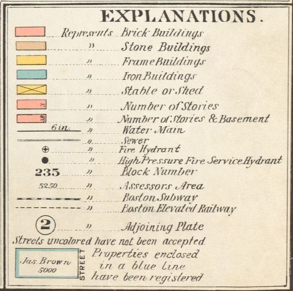
George Washington Bromley published real estate atlases showing a myriad of neighborhood information. Bromley worked for Griffith M. Hopkins before starting his own publishing company with brother Walter Scott Bromley. These atlases are often used to explore the locations of individuals or businesses, for information about construction history, or for details that can help value property. Bromley atlases are published in volumes covering one or two neighborhoods. The Map & Education Center's Bromley atlases span 1883-1938.
| Shows | Varies by atlas/year |
|---|---|
| Street numbers Property owners Building composition (brick, stone, frame, etc.) Businesses Public buildings Water mains Sewers Fire hydrants Block numbers Assessors areas |
Building structure (floors and basement) Subway Boston Elevated Railway |
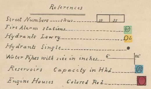
Hopkin's Atlas of Suffolk County
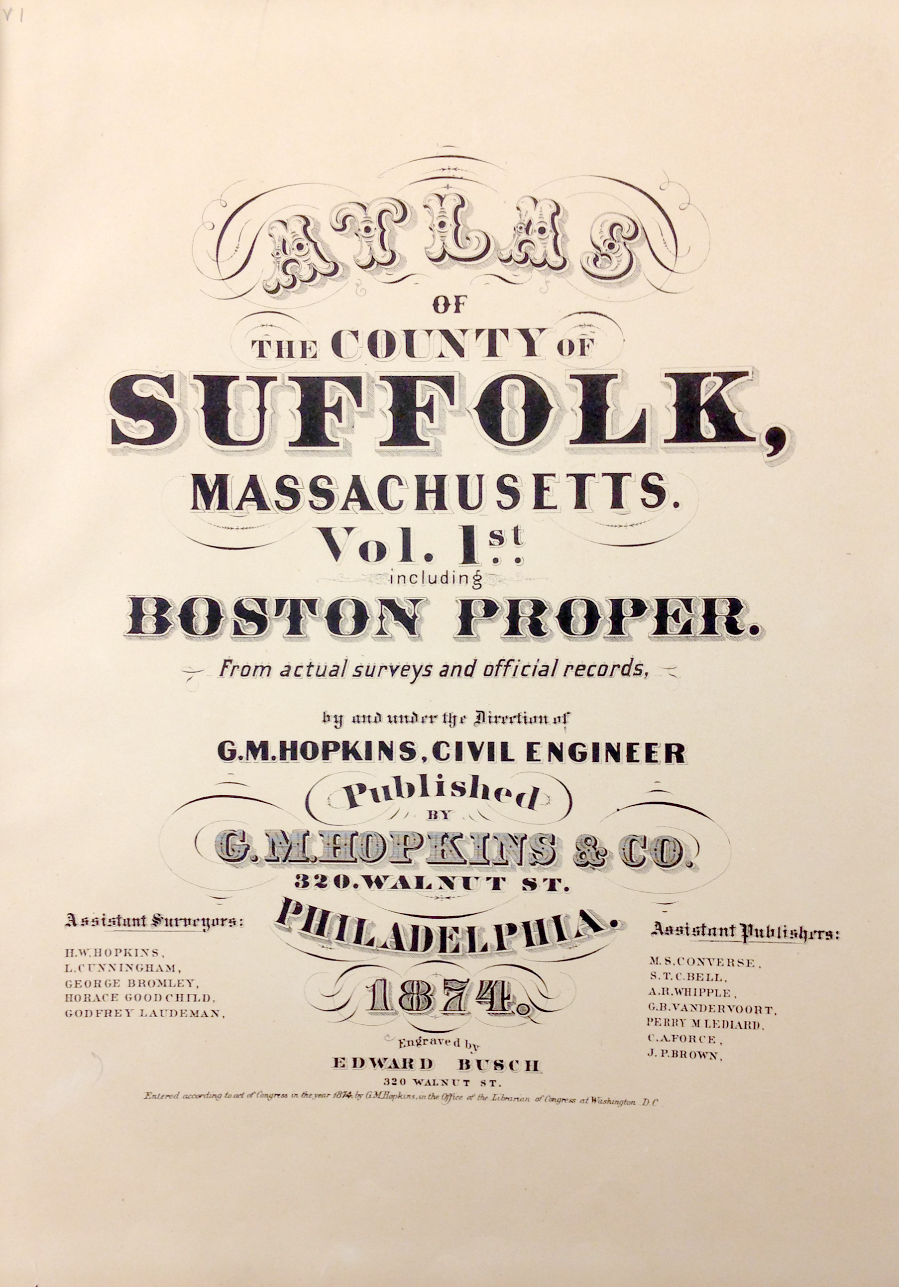
Griffith Morgan Hopkins was a Philadelphia publisher known for his city atlases. His Atlas of the County of Suffolk, Massachusetts is a seven volume set covering Suffolk County from 1873 to 1875. Hopkins' atlases display building ownership identification for most buildings among other important information about Boston during the time.
- Volume 1: Boston Proper
- Volume 2: Roxbury
- Volume 3: South Boston and Dorchester
- Volume 4: East Boston, Chelsea, Revere, and Winthrop
- Volume 5: West Roxbury
- Volume 6: Charlestown
- Volume 7: Brighton
| Shows | Does not show |
|---|---|
|
Street numbers |
Building composition (brick, wood, etc.) Businesses Building structure (floors, windows, etc.) |
Pinney's Plan of the City of Boston
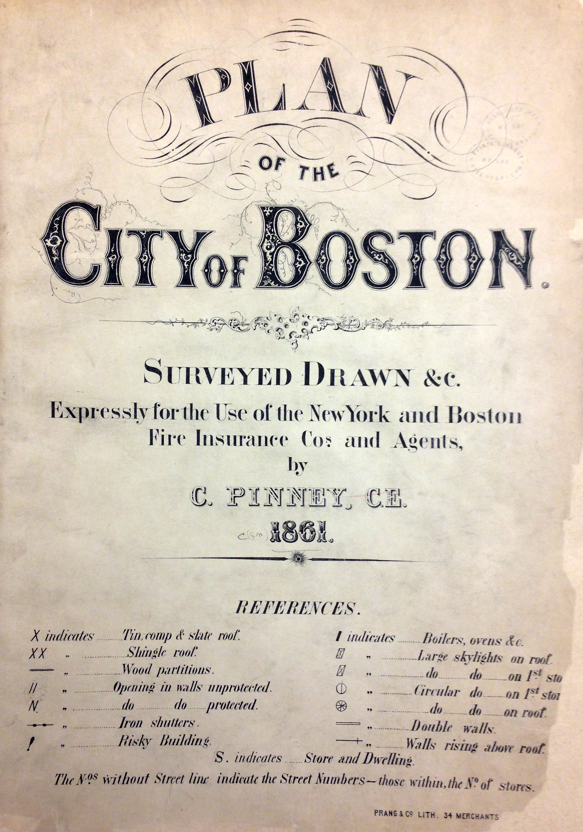
The Plan of the City of Boston by Charles E. Pinney is the first fire insurance atlas of Boston, published in 1861. The atlas contains 25 plates of the downtown Boston area and assesses buildings for fire risk.
| Shows | Does not show |
|---|---|
| Street numbers Building composition Building features "Risky" buildings Public Buildings Stores |
Property owners |
Sanborn Fire Insurance Atlases
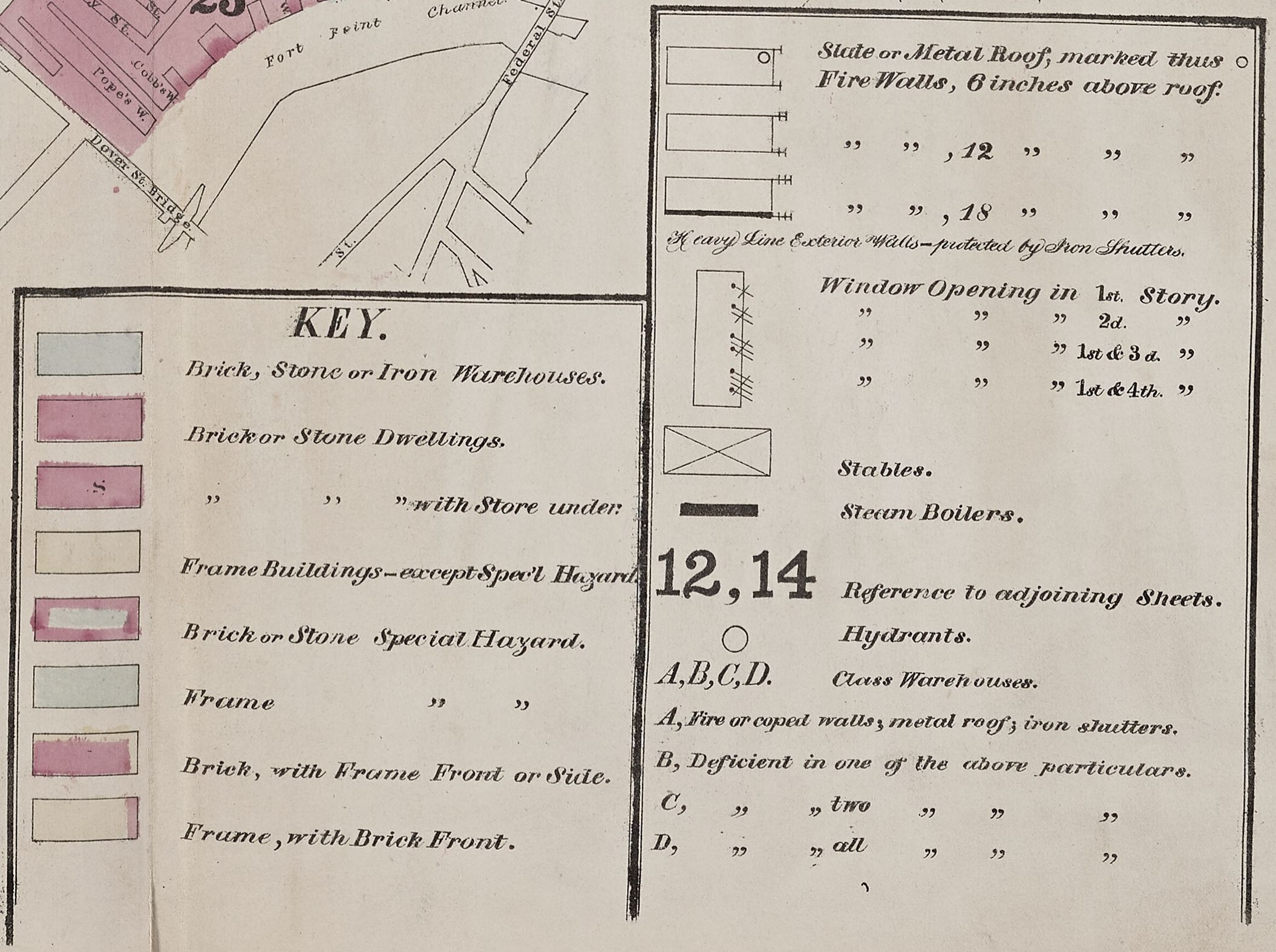 The Sanborn Map Company published approximately 700,000 atlas plates made for over 12,000 North American cities and towns, from 1876 onward. These atlases were originally made as a utility to fire insurance underwriters, however their standardized labels and systematic style has made them very suitable for historical research of North American buildings and neighborhoods, and their changes over time.
- Legend from a 1976 Sanborn
- Color key from Library of Congress
- Glossary of abbreviations from California State University, Northridge (CSUN) Map Library
| Shows | Does not show |
|---|---|
| Street numbers Building composition Building structure Businesses Public buildings Fire hydrants |
Property owners |
Sanborn Atlases at the Boston Public Library

The Sanborn atlas collection at the Norman B. Leventhal Map & Education Center at the Boston Public Library consists of:
- Daniel A. Sanborn's first Insurance Map of Boston from1867 and 1870 update
- Insurance Map of Charlestown from 1868 and 1871 update
- A four volume set originally published 1873-1876 with paste-up corrections to 1885
- Sanborn Map Company's 11 volume set published in the 1920s with paste-up corrections to 1963
- Later sets published in black-and-white from 1974, 1979, 1981, 1986 and 1988.
The most complete collection of Sanborn atlases belongs to the Library of Congress in Washington, D.C. In the 1970s and 80s, the entire collection of atlases was scanned and formatted into microfilm. The Boston Public Library's copy of Sanborn Fire Insurance Maps, Massachusetts, [1867-1950] is available through the Microtext Department. The Microtext Department also holds Fire Insurance Maps From the Sanborn Map Company Archives, Late 19th Century to 1990, Massachusetts.
Additional Resources for Finding and Using Sanborn Atlases
About the Sanborn Map Collection at the Library of Congress
The Library of Congress's Geography and Map Division holds the largest collection of Sanborn Atlases. The collection, with coverage spanning the entire United States, is searchable online with more than 6,000 of their sheets are available to view in digital format. Along with the collection comes a thorough description of the colors and legend found within the atlases.
The Union List of Sanborn and Other Fire Insurance Atlases
University of California Berkeley maintains the Union List of Sanborn and Other Fire Insurance Atlases, which lists Sanborn atlases for the United States, Canada, and Mexico, and includes corrections, additions, and changes of ownership. The list also provides links to free versions of atlases when they are available over the web.
Fire Insurance Maps in the Library of Congress
In 1967 the U.S. Bureau of the Census transferred a large number of Sanborn atlases to the Library of Congress, which contained many later editions than those previously held by the Library of Congress. In the 1970s, the Library of Congress compiled a checklist of their atlases, which was then published to make this very informative reference book. It is available for in-Library use at the BPL during departmental research hours.
Environmental Data Resources Inc.
In the 1990s Environmental Data Resources Inc. (EDR) became the copyright holders of all Sanborn Maps, and uses of the maps today are restricted under their license. For those wishing to use Sanborn Maps in publications, research, or commercially, EDR is the place to begin your investigation. Their website also provides some useful starting points and historical information about their Sanborn Map collection.