Fire Insurance and Real Estate Atlases of Boston at the BPL
Norman B. Leventhal Map & Education Center - Hours
See the Norman B. Leventhal Map & Education Center gallery hours, special hours, and research hours on their website.
Remote Reference and Research Services:
https://www.leventhalmap.org/research/
How Do I See the Atlases?
Schedule an appointment to view specific materials at readingroom.bpl.org.
If you aren’t sure what you’d like to see, write to us! Our staff are happy to help you search for items relevant to your interests.
Related Resources

-
Massachusetts State Library Atlas Digitization ProjectReal estate atlases digitized and online in Flickr albums and as PDFs.
-
Library of Congress Sanborn Maps CollectionSanborn atlases of various U.S. cities digitized by the Library of Congress
-
Researching Your HomePost about researching the history of your home and the people who lived in it
-
How to Research a Historic Building in Boston (.PDF)Guide to additional resources for researching buildings in Boston from the Boston Landmarks Commission.
Finding a map using the street or address
For other towns, see the Historical Urban Atlases of Massachusetts Towns Guide.
- Click on a neighborhood in the menu on the left to jump to that section.
- If you do not know the neighborhood, look up the street in A record of the streets, alleys, places, etc. in the city of Boston. Neighborhoods are noted by the abbreviation after the street name.
- Find an atlas close to your year of interest, and click on "Digitized Atlas" to see the full atlas.
- Look for a street index (usually right after the title page), and look up the street and corresponding plate number.
*Not all atlases have street indexes. If your chosen atlas does not have a street index or doesn't list your street, choose another year. You are trying to find the geographic location of the street, which allows you to use atlases for other years.
- Next, look for the index map (usually right after the street index), which shows the areas covered by the plates in the atlas. Find the geographic location of the plate for your street.
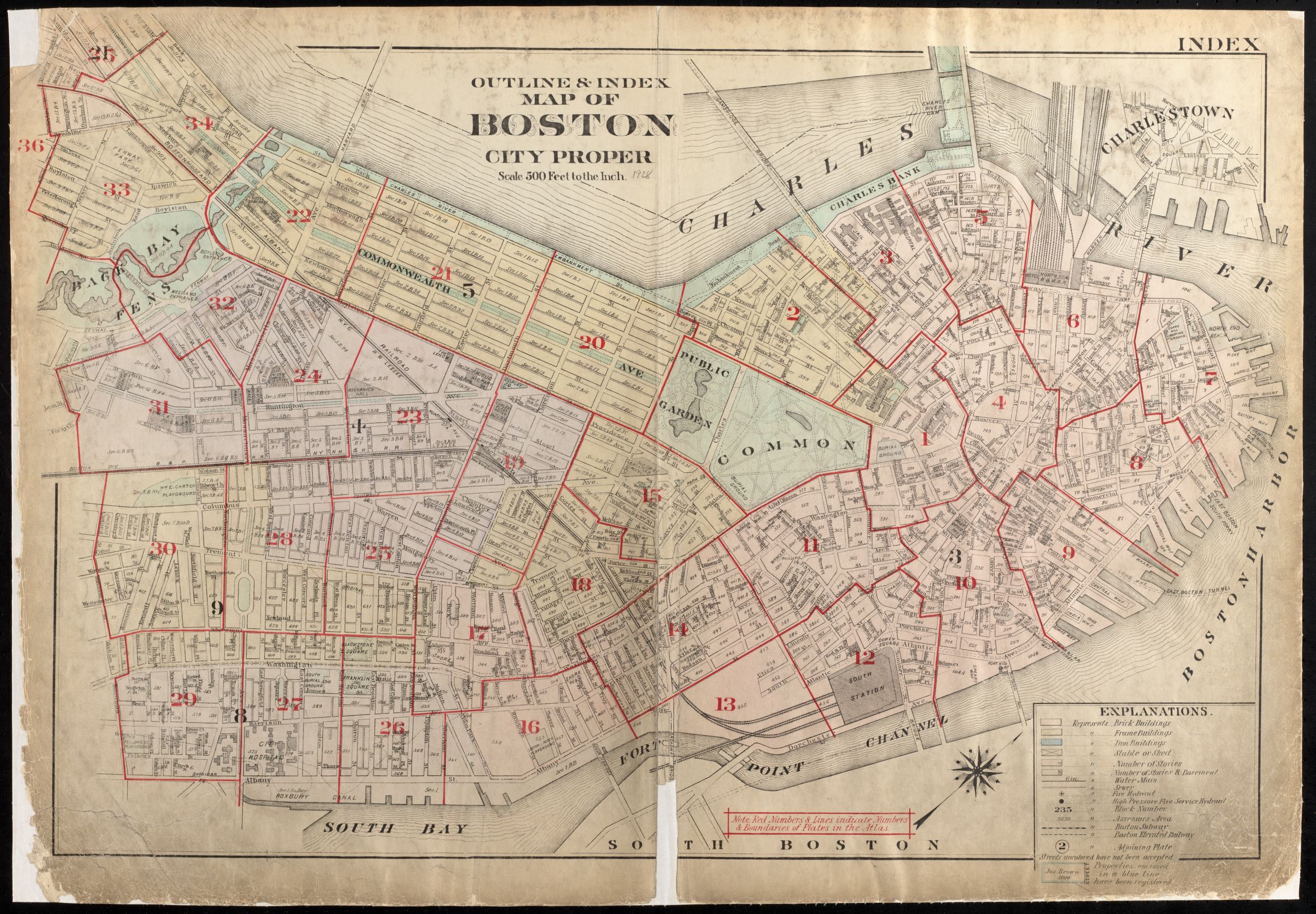
- Knowing the geographic location of the street, you can now use Atlascope to see all maps covering that area.
Boston Proper
1861
Pinney, C. (1861). Plan of the City of Boston. Boston: Prang & Co. Lith. Boston.
Catalog Record | Digitized Atlas | Index map
1867
Sanborn, Daniel A. (1867). Insurance Map of Boston. Vol. 1. New York: D.A. Sanborn. Boston.
Catalog Record | Digitized Atlas | Index map
1868
Sanborn, Daniel A. (1868). Insurance Map of Boston. Vol. 2. New York: D.A. Sanborn. Boston.
Catalog Record | Digitized Atlas | Index map
1870
Sanborn, Daniel A. (1868). Insurance Map of Boston. Vol. 2. New York: D.A. Sanborn. Boston.
Catalog Record | Digitized Atlas | Index map | Corrected to October, 1870
1873
Hopkins, Griffith Morgan, Jr. (1873). Atlas of the county of Suffolk, Massachusetts from actual surveys and official records. Vol. 2. Philadelphia: G.M. Hopkins & Co. Late city of Roxbury, now wards 13, 14, and 15, city of Boston.
Catalog Record | Digitized Atlas | Index map
1874
F.W. Beers & Co. (1874). Fire insurance district atlas showing the fire insurance districts of the city of Boston. New York : F.W. Beers & Co. Boston.
Catalog Record | Digitized Atlas | Index map
Hopkins, Griffith Morgan, Jr. (1874). Atlas of the county of Suffolk, Massachusetts from actual surveys and official records. Vol. 1. Philadelphia: G.M. Hopkins & Co. Boston Proper.
Catalog Record | Digitized Atlas | Index map
1882
Hopkins, Griffith Morgan, Jr. (1882). City Atlas of Boston, Massachusetts Complete in One Volume, From Official Records, Private Plans and Actual Surveys. Philadelphia: G.M. Hopkins.
Catalog Record | Digitized Atlas | Index map
Sanborn, Daniel A. (1873). Insurance Maps of Boston Volume 1. New York: D.A. Sanborn. Boston Proper.
Catalog Record | Digitized Atlas | Index Map | Corrected to March, 1882
1883
G.W. Bromley & Co. (1883). Atlas of the City of Boston, Mass, Vol. 1 City Proper, From Actual Surveys and Official Plans. Philadelphia: Geo. W. and Walter S. Bromley. Vol. 1 City Proper.
Catalog Record | Digitized Atlas | Index map
1885
Sanborn, Daniel A. (1874). Insurance Maps of Boston Volume 2. New York: D.A. Sanborn.
Catalog Record | Digitized Atlas | Index map | Lacking plate 44. Corrected to July, 1885
1888
Bromley, George Washington. (1888). Atlas of the City of Boston, Vol. 1 City Proper, From Actual Surveys and Official Plans. Philadelphia: G.W. Bromley & Co. Vol. 1 City Proper.
Catalog Record | Digitized Atlas | Index map
Bromley, George Washington. (1888). Atlas of the City of Boston, Vol. 2 City Proper, From Actual Surveys and Official Plans. Philadelphia: G.W. Bromley & Co. Vol. 2 City Proper.
Catalog Record | Digitized Atlas | Index map
1890
Bromley, George Washington. (1890). Atlas of the City of Boston, City Proper and Roxbury: From Actual Surveys and Official Plans. Philadelphia: G.W. Bromley & Co. Boston Proper and Roxbury.
Catalog Record | Digitized Atlas | Index map
1895
Bromley, George Washington. (1895). Atlas of the City of Boston, Boston Proper and Roxbury, From Actual Surveys and Official Plans. Philadelphia: G.W. Bromley & Co. Boston Proper and Roxbury.
Catalog Record | Digitized Atlas | Index map
1898
Bromley, George Washington. (1898). Atlas of the City of Boston, Boston Proper From Actual Surveys and Official Plans. Philadelphia: G.W. Bromley & Co. Boston Proper.
Catalog Record | Digitized Atlas| Index map
1902
Bromley, George Washington. (1902). Atlas of the City of Boston, Boston Proper and Back Bay: From Actual Surveys and Official Plans. Philadelphia: G.W. Bromley & Co. Boston Proper and Back Bay.
Catalog Record | Digitized Atlas | Index map
1908
Bromley, George Washington. (1908). Atlas of the City of Boston, Boston Proper and Back Bay: From Actual Surveys and Official Plans. Philadelphia: G.W. Bromley & Co. Boston Proper and Back Bay.
Catalog Record | Digitized Atlas | Index map
1912
Bromley, George Washington. (1912). Atlas of the City of Boston, Boston Proper, and Back Bay: From Actual Surveys and Official Plans. Philadelphia: G.W. Bromley & Co. Boston Proper and Back Bay.
Catalog Record | Digitized Atlas | Index map
1917
G.W. Bromley & Co. (1917). Atlas of the City of Boston, Boston Proper and Back Bay, From Actual Surveys and Official Plans. Philadelphia: G.W. Bromley & Co. Boston Proper and Back Bay.
Catalog Record | Digitized Atlas | Index map
1922
Bromley, George Washington. (1922). Atlas of the City of Boston, Boston Proper and Back Bay: From Actual Surveys and Official Plans. Philadelphia: G.W. Bromley & Co. Boston Proper and Back Bay.
Catalog Record | Digitized Atlas | Index map
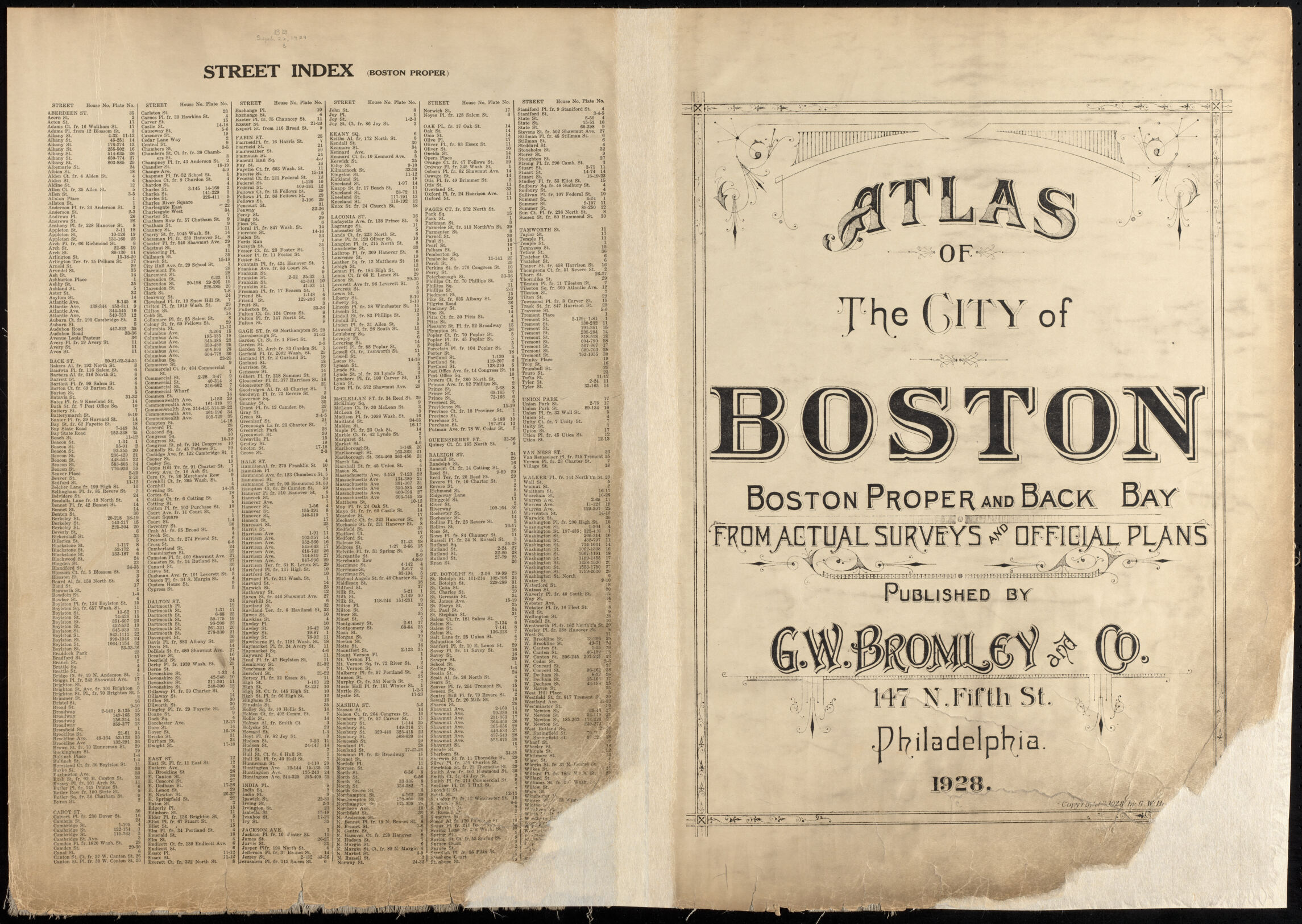
1928
G.W. Bromley & Co. (1928). Atlas of the City of Boston, Boston Proper and Back Bay: From Actual Surveys and Official Plans. Philadelphia: G.W. Bromley & Co. Boston Proper and Back Bay.
Catalog Record | Digitized Atlas | Index map
1938
G.W. Bromley & Co. (1938). Atlas of the City of Boston, Boston Proper and Back Bay: From Actual Surveys and Official Plans. Philadelphia: G.W. Bromley & Co. Boston Proper and Back Bay.
Catalog Record | Digitized Atlas | Index map
1962
(1962). City of Boston: topographic and planimetric survey. Boston: Boston Redevelopment Authority,
Catalog Record | Digitized Atlas
1963
Sanborn Map Company. (1929). Insurance maps of Boston, Massachusetts. Vol. 1. New York: Sanborn Map Company. Boston Proper North.
Catalog Record | Index map | Corrected to June, 1963
Sanborn Map Company. (1929). Insurance maps of Boston, Massachusetts. Vol. 1. New York: Sanborn Map Company. Boston Proper South.
Catalog Record | Index map | Corrected to June, 1963
Sanborn Map Company. (1937). Insurance maps of Boston, Massachusetts. Vol. 2. New York: Sanborn Map Company. Boston Back Bay North.
Catalog Record | Index map | Corrected to July, 1963
Sanborn Map Company. (1938). Insurance maps of Boston, Massachusetts. Vol. 2. New York: Sanborn Map Company. Boston Back Bay South.
Catalog Record | Index map | Corrected to July, 1963
1964
Sanborn Map Company. Insurance maps of Boston, Massachusetts. Vols. 1 North, 1 South, 2 North, 2 South.
Catalog Record (microfilm at Central Library Research Services)
1975
Sanborn Map Company. (June 1975). Boston, Mass. Vol. 1-S. New York: Sanborn Map Company. South.
Catalog Record
Sanborn Map Company. (June 1975). Boston, Mass. Vol. 2-N. New York: Sanborn Map Company. North.
Catalog Record
1976
Sanborn Map Company. (July 1976). Boston, Mass. Vol. 1-N. New York: Sanborn Map Company. North.
Catalog Record
Sanborn Map Company. (July 1976). Boston, Mass. Vol. 2-S. New York: Sanborn Map Company. South.
Catalog Record
1979
Sanborn Map Company. (September 1979). Boston, Mass. Vol. 2-S. New York: Sanborn Map Company.
Catalog Record
1981
Sanborn Map Company. (August 1981). Boston, Mass. Vol. 1-N. New York: Sanborn Map Company. South.
Catalog Record
Sanborn Map Company. (August 1981). Boston, Mass. Vol. 1-S. New York: Sanborn Map Company. South.
Catalog Record
Sanborn Map Company. (September 1981). Boston, Mass. Vol. 2-N. New York: Sanborn Map Company. North.
Catalog Record
Sanborn Map Company. (September 1981). Boston, Mass. Vol. 2-S. New York: Sanborn Map Company. South.
Catalog Record
1986
Sanborn Map Company. (September 1986). Boston, Mass. Vol. 1-N. New York: Sanborn Map Company. South.
Catalog Record
Sanborn Map Company. (September 1986). Boston, Mass. Vol. 1-S. New York: Sanborn Map Company. South.
Catalog Record
Sanborn Map Company. (October 1986). Boston, Mass. Vol. 2-N. New York: Sanborn Map Company. North.
Catalog Record
Sanborn Map Company. (October 1986). Boston, Mass. Vol. 2-S. New York: Sanborn Map Company. South.
Catalog Record
1990
Sanborn Map Company. Insurance maps of Boston, Massachusetts. Vols. 1 North, 1 South, 2 North, 2 South.
Catalog Record (microfilm at Central Library Research Services)
Brighton
1875
Hopkins, Griffith Morgan, Jr. (1875). Atlas of the county of Suffolk, Massachusetts from actual surveys and official records. Vol. 7. Philadelphia: G.M. Hopkins & Co. The late town of Brighton, now ward 19 of Boston.
Catalog Record | Digitized Atlas | Index map
1882
Hopkins, Griffith Morgan, Jr. (1882). City Atlas of Boston, Massachusetts Complete in One Volume, From Official Records, Private Plans and Actual Surveys. Philadelphia: G.M. Hopkins.
Catalog Record | Digitized Atlas | Index map
1885
G.W. Bromley & Co. (1885). Atlas of the City of Boston, Mass, Vol. 6. Charlestown and Brighton, From Actual Surveys and Official Plans. Philadelphia: Geo. W. and Walter S. Bromley. Vol. 6 Charlestown and Brighton.
Catalog Record | Digitized Atlas | Index map
1890
Bromley, George Washington. (1890). Atlas of the City of Boston, Vol. 7. Brighton, From Actual Surveys and Official Plans. Philadelphia: G.W. Bromley & Co. Vol. 7 Brighton.
Catalog Record | Digitized Atlas | Index map
1897
Bromley, George Washington. (1897). Atlas of the City of Boston, Vol. 7, Brighton From Actual Surveys and Official Plans. Philadelphia: G.W. Bromley & Co. Vol. 5, Brighton.
Catalog Record | Digitized Atlas | Index map
1899
Richards, L. J. (1899). Atlas of Dorchester, West Roxbury and Brighton, City of Boston. Boston: L.J. Richards. Dorchester, West Roxbury and Brighton.
Catalog Record | Digitized Atlas | Index map
1909
Bromley, George Washington. (1909). Atlas of the City of Boston, Ward 25, Brighton: From Actual Surveys and Official Plans. Philadelphia: G.W. Bromley & Co. Ward 25, Brighton.
Catalog Record | Digitized Atlas | Index map
1916
Bromley, George Washington. (1916). Atlas of the City of Boston, Brighton: From Actual Surveys and Official Plans. Philadelphia: G.W. Bromley. Brighton.
Catalog Record | Digitized Atlas | Index map
1925
Bromley, George Washington. (1925). Atlas of the City of Boston, Brighton: From Actual Surveys and Official Plans. Philadelphia: G.W. Bromley & Co. Brighton.
Catalog Record | Digitized Atlas | Index map
1961
Sanborn Map Company. (1925). Insurance maps of Boston, Massachusetts. Vol. 6. New York: Sanborn Map Company. Brighton.
Catalog Record | Index map | Corrected to July, 1961
1962
(1962). City of Boston: topographic and planimetric survey. Boston: Boston Redevelopment Authority,
Catalog Record | Digitized Atlas
1964
Sanborn Map Company. Insurance maps of Boston, Massachusetts. Vol. 6.
Catalog Record (microfilm at Central Library Research Services)
1977
Sanborn Map Company. (October 1977). Boston, Mass. Vol. 6. New York: Sanborn Map Company. Brighton.
Catalog Record
1981
Sanborn Map Company. (February 1981). Boston, Mass. Vol. 6. New York: Sanborn Map Company. Brighton.
Catalog Record
1986
Sanborn Map Company. (February 1986). Boston, Mass. Vol. 6. New York: Sanborn Map Company. Brighton.
Catalog Record
1988
Sanborn Map Company. (June 1988). Boston, Mass. Vol. 6. New York: Sanborn Map Company. Brighton.
Catalog Record
1990
Sanborn Map Company. Insurance maps of Boston, Massachusetts. Vol. 6.
Catalog Record (microfilm at Central Library Research Services)
Charlestown
1868
Sanborn, Daniel A. (1868). Insurance map of Charlestown portions of Roxbury (now annexed to Boston) and Cambridge. New York: D.A. Sanborn. Charlestown, Roxbury, and Cambridge.
Catalog Record | Digitized Atlas | Index map
1871
Sanborn, Daniel A. (1868). Insurance map of Charlestown portions of Roxbury (now annexed to Boston) and Cambridge. New York: D.A. Sanborn. Charlestown, Roxbury, and Cambridge.
Catalog Record | Digitized Atlas | Index map | Corrected to November, 1871
1875
Hopkins, Griffith Morgan, Jr. (1875). Atlas of the county of Suffolk, Massachusetts from actual surveys and official records. Vol. 6. Philadelphia: G.M. Hopkins & Co. Including the late city of Charlestown, now wards 20, 21, and 22, city of Boston.
Catalog Record | Digitized Atlas | Index map
1882
Hopkins, Griffith Morgan, Jr. (1882). City Atlas of Boston, Massachusetts Complete in One Volume, From Official Records, Private Plans and Actual Surveys. Philadelphia: G.M. Hopkins.
Catalog Record | Digitized Atlas | Index map
1885
G.W. Bromley & Co. (1885). Atlas of the City of Boston, Mass, Vol. 6. Charlestown and Brighton, From Actual Surveys and Official Plans. Philadelphia: Geo. W. and Walter S. Bromley. Vol. 6 Charlestown and Brighton.
Catalog Record | Digitized Atlas | Index map
Sanborn, Daniel A. (1876). Insurance Maps of Boston Volume 4: comprising portions of Charlestown, East Cambridge, Cambridge Port, Old Cambridge & Somerville . New York: Sanborn Map & Publishing Co.
Catalog Record | Digitized Atlas | Index map | Corrected to June, 1885
1892
Bromley, George Washington. (1892). Atlas of the City of Boston, Vol. 10 Charlestown, From Actual Surveys and Official Plans. Philadelphia: G.W. Bromley & Co. Vol. 10 Charlestown.
Catalog Record | Digitized Atlas | Index map
1901
Bromley, George Washington. (1901). Atlas of the City of Boston, Charlestown: From Actual Surveys and Official Plans. Philadelphia: G.W. Bromley & Co. Charlestown.
Catalog Record | Digitized Atlas | Index map
1912
Bromley, George Washington. (1912). Atlas of the City of Boston, Charlestown and East Boston: From Actual Surveys and Official Plans. Philadelphia: G.W. Bromley & Co. Charlestown and East Boston.
Catalog Record | Digitized Atlas | Index map
1922
Bromley, George Washington. (1922). Atlas of the City of Boston, Charlestown and East Boston: From Actual Surveys and Official Plans. Philadelphia: G.W. Bromley & Co. Charlestown and East Boston.
Catalog Record | Digitized Atlas | Index map
1962
(1962). City of Boston: topographic and planimetric survey. Boston: Boston Redevelopment Authority,
Catalog Record | Digitized Atlas
1963
Sanborn Map Company. (1927). Insurance maps of Boston, Massachusetts. Vol. 5. New York: Sanborn Map Company. East Boston and Charlestown.
Catalog Record | Index | Corrected to July, 1963
1964
Sanborn Map Company. Insurance maps of Boston, Massachusetts. Vol. 5-W.
Catalog Record (microfilm at Central Library Research Services)
1976
Sanborn Map Company. (September 1976). Boston, Mass. Vol. 5-W. New York: Sanborn Map Company. West, including Charlestown.
Catalog Record
1978
Sanborn Map Company. (July 1978). Boston, Mass. Vol. 5-W. New York: Sanborn Map Company. West, including Charlestown.
Catalog Record
1981
Sanborn Map Company. (November 1981). Boston, Mass. Vol. 5-W. New York: Sanborn Map Company. West, including Charlestown.
Catalog Record
1987
Sanborn Map Company. (June 1987). Boston, Mass. Vol. 5-W. New York: Sanborn Map Company. West, including Charlestown.
Catalog Record
1990
Sanborn Map Company. Insurance maps of Boston, Massachusetts. Vol. 5-W.
Catalog Record (microfilm at Central Library Research Services)
Dorchester
1874
Hopkins, Griffith Morgan, Jr. (1874). Atlas of the county of Suffolk, Massachusetts from actual surveys and official records. Vol. 3. Philadelphia: G.M. Hopkins & Co. Including South Boston and Dorchester.
Catalog Record | Digitized Atlas | Index map | 1:1,800 Map | 1: 7,200 Map
1882
Hopkins, Griffith Morgan, Jr. (1882). City Atlas of Boston, Massachusetts Complete in One Volume, From Official Records, Private Plans and Actual Surveys. Philadelphia: G.M. Hopkins.
Catalog Record | Digitized Atlas | Index map
1884
G.W. Bromley & Co. (1884). Atlas of the City of Boston, Mass, Vol. 3. Dorchester, From Actual Surveys and Official Plans. Philadelphia: Geo. W. and Walter S. Bromley. Vol. 3 Dorchester.
Catalog Record | Digitized Atlas | Index map
1889
Bromley, George Washington. (1889). Atlas of the City of Boston, Vol. 5. Dorchester, From Actual Surveys and Official Plans. Philadelphia: G.W. Bromley & Co. Vol. 5 Dorchester.
Catalog Record | Digitized Atlas | Index map
1894
Bromley, George Washington. (1894). Atlas of the City of Boston, Vol. 5, Dorchester, Mass From Actual Surveys and Official Plans. Philadelphia: G.W. Bromley & Co. Vol. 5, Dorchester.
Catalog Record | Digitized Atlas | Index map
1898
Bromley, George Washington. (1898). Atlas of the City of Boston, Vol. 5, Dorchester, Mass: From Actual Surveys and Official Plans. Philadelphia: G.W. Bromley. Vol. 5, Dorchester.
Catalog Record | Digitized Atlas | Index map
1899
Richards, L. J. (1899). Atlas of Dorchester, West Roxbury and Brighton, City of Boston. Boston: L.J. Richards. Dorchester, West Roxbury and Brighton.
Catalog Record | Digitized Atlas | Index map
1904
Bromley, George Washington. (1904). Atlas of the City of Boston, Vol. 5, Dorchester, Mass: From Actual Surveys and Official Plans. Philadelphia: G.W. Bromley. Vol. 5, Dorchester.
Catalog Record | Digitized Atlas | Index map
1910
Bromley, George Washington. (1910). Atlas of the City of Boston, Dorchester: From Actual Surveys and Official Plans. Philadelphia: G.W. Bromley. Dorchester.
Catalog Record | Digitized Atlas | Index map
1918
Bromley, George Washington. (1918). Atlas of the City of Boston, Dorchester: From Actual Surveys and Official Plans. Philadelphia: G.W. Bromley & Co. Dorchester.
Catalog Record | Digitized Atlas | Index map
1929
Sanborn Map Company. (1899). Insurance maps of Boston, Massachusetts. Vol. 8. New York: Sanborn Map Company. Part of Dorchester and Roxbury.
Catalog Record | Corrected to December, 1929
1933
G.W. Bromley & Co. (1933). Atlas of the City of Boston, Dorchester: From Actual Surveys and Official Plans. Philadelphia: G.W. Bromley & Co. Dorchester.
Catalog Record | Digitized Atlas | Index map
1962
(1962). City of Boston: topographic and planimetric survey. Boston: Boston Redevelopment Authority,
Catalog Record | Digitized Atlas
Sanborn Map Company. (1931). Insurance maps of Boston, Massachusetts. Vol. 8. New York: Sanborn Map Company. Part of Dorchester and Roxbury.
Catalog Record | Index map | Corrected to December, 1962
1963
Sanborn Map Company. (1923). Insurance maps of Boston, Massachusetts. Vol. 4. New York: Sanborn Map Company. South Boston.
Catalog Record | Index map | Corrected to August, 1963
Sanborn Map Company. (1931). Insurance maps of Boston, Massachusetts. Vol. 9. New York: Sanborn Map Company. Part of Dorchester.
Catalog Record | Index map | Corrected to August, 1963
Sanborn Map Company. (1930). Insurance maps of Boston, Massachusetts. Vol. 11. New York: Sanborn Map Company. Hyde Park and parts of Dorchester and West Roxbury.
Catalog Record | Index map | Corrected to September, 1963
1964
Sanborn Map Company. Insurance maps of Boston, Massachusetts. Vols. 4, 8, 9 (lacking pages 1-32), 11.
Catalog Record (microfilm at Central Library Research Services)
1977
Sanborn Map Company. (August 1977). Boston, Mass. Vol. 4. New York: Sanborn Map Company. South Boston & part of Dorchester.
Catalog Record
1978
Sanborn Map Company. (March 1978). Boston, Mass. Vol. 8. New York: Sanborn Map Company. Part of Dorchester & Roxbury.
Catalog Record
Sanborn Map Company. (March 1978). Boston, Mass. Vol. 9. New York: Sanborn Map Company. Part of Dorchester.
Catalog Record
Sanborn Map Company. (March 1978). Boston, Mass. Vol. 11. New York: Sanborn Map Company. Hyde Park & parts of Dorchester & West Roxbury.
Catalog Record
1979
Sanborn Map Company. (February 1979). Boston, Mass. Vol. 8. New York: Sanborn Map Company. Part of Dorchester & Roxbury.
Catalog Record
Sanborn Map Company. (March 1979). Boston, Mass. Vol. 9. New York: Sanborn Map Company. Part of Dorchester.
Catalog Record
Sanborn Map Company. (April 1979). Boston, Mass. Vol. 11. New York: Sanborn Map Company. Hyde Park & parts of Dorchester & West Roxbury.
Catalog Record
1981
Sanborn Map Company. (October 1981). Boston, Mass. Vol. 4. New York: Sanborn Map Company. South Boston & part of Dorchester.
Catalog Record
Sanborn Map Company. (March 1981). Boston, Mass. Vol. 8. New York: Sanborn Map Company. Part of Dorchester & Roxbury.
Catalog Record
Sanborn Map Company. (March 1981). Boston, Mass. Vol. 9. New York: Sanborn Map Company. Part of Dorchester.
Catalog Record
Sanborn Map Company. (April 1981). Boston, Mass. Vol. 11. New York: Sanborn Map Company. Hyde Park & parts of Dorchester & West Roxbury.
Catalog Record
1986
Sanborn Map Company. (November 1986). Insurance maps of Boston, Massachusetts. Vol. 4. New York: Sanborn Map Company. South Boston.
Catalog Record
Sanborn Map Company. (January 1986). Boston, Mass. Vol. 8. New York: Sanborn Map Company. Part of Dorchester & Roxbury.
Catalog Record
Sanborn Map Company. (January 1986). Boston, Mass. Vol. 9. New York: Sanborn Map Company. Part of Dorchester.
Catalog Record
Sanborn Map Company. (January 1986). Boston, Mass. Vol. 11. New York: Sanborn Map Company. Hyde Park & parts of Dorchester & West Roxbury.
Catalog Record
1987
Sanborn Map Company. (November 1987). Insurance maps of Boston, Massachusetts. Vol. 4. New York: Sanborn Map Company. South Boston.
Catalog Record
1988
Sanborn Map Company. (June 1988). Boston, Mass. Vol. 8. New York: Sanborn Map Company. Part of Dorchester & Roxbury.
Catalog Record
Sanborn Map Company. (June 1988). Boston, Mass. Vol. 11. New York: Sanborn Map Company. Hyde Park & parts of Dorchester & West Roxbury.
Catalog Record
1990
Sanborn Map Company. Insurance maps of Boston, Massachusetts. Vols. 4, 8, 9, 11.
Catalog Record (microfilm at Central Library Research Services)
East Boston
Sanborn, Daniel A. (1868). Insurance Map of Boston. Vol. 2. New York: D.A. Sanborn. Boston.
Catalog Record | Digitized Atlas | Index map
1870
Sanborn, Daniel A. (1868). Insurance Map of Boston. Vol. 2. New York: D.A. Sanborn. Boston.
Catalog Record | Digitized Atlas | Index map | Corrected to October, 1870
1874
Hopkins, Griffith Morgan, Jr. (1874). Atlas of the county of Suffolk, Massachusetts from actual surveys and official records. Vol. 4. Philadelphia: G.M. Hopkins & Co. Including East Boston, city of Chelsea, Revere, and Winthrop.
Catalog Record | Digitized Atlas | Index map
1882
Hopkins, Griffith Morgan, Jr. (1882). City Atlas of Boston, Massachusetts Complete in One Volume, From Official Records, Private Plans and Actual Surveys. Philadelphia: G.M. Hopkins.
Catalog Record | Digitized Atlas | Index map
1884
G.W. Bromley & Co. (1884). Atlas of the City of Boston, Mass, Vol. 4. South and East Boston, From Actual Surveys and Official Plans. Philadelphia: Geo. W. and Walter S. Bromley. Vol. 4 South and East Boston.
Catalog Record | Digitized Atlas | Index map
1885
Sanborn, Daniel A. (1875). Insurance Maps of Boston Volume 3: South and East Boston. New York: D.A. Sanborn.
Catalog Record | Digitized Atlas | Index map | Corrected to June, 1885
1892
Bromley, George Washington. (1892). Atlas of the City of Boston, Vol. 9. East Boston, From Actual Surveys and Official Plans. Philadelphia: G.W. Bromley & Co. Vol. 9 East Boston.
Catalog Record | Digitized Atlas | Index map
1901
Bromley, George Washington. (1901). Atlas of the City of Boston, East Boston: From Actual Surveys and Official Plans. Philadelphia: G.W. Bromley & Co. East Boston.
Catalog Record | Digitized Atlas | Index map
1912
Bromley, George Washington. (1912). Atlas of the City of Boston, Charlestown and East Boston: From Actual Surveys and Official Plans. Philadelphia: G.W. Bromley & Co. Charlestown and East Boston.
Catalog Record | Digitized Atlas | Index map
1922
Bromley, George Washington. (1922). Atlas of the City of Boston, Charlestown and East Boston: From Actual Surveys and Official Plans. Philadelphia: G.W. Bromley & Co. Charlestown and East Boston.
Catalog Record | Digitized Atlas | Index map
1962
(1962). City of Boston: topographic and planimetric survey. Boston: Boston Redevelopment Authority,
Catalog Record | Digitized Atlas
1963
Sanborn Map Company. (1927). Insurance maps of Boston, Massachusetts. Vol. 5. New York: Sanborn Map Company. East Boston and Charlestown.
Catalog Record | Index map | Corrected to July, 1963
1964
Sanborn Map Company. Insurance maps of Boston, Massachusetts. Vol. 5-E.
Catalog Record (microfilm at Central Library Research Services)
1973
Sanborn Map Company. (October 1973). Boston, Mass. Vol. 5-E. New York: Sanborn Map Company. Including East Boston.
Catalog Record
1975
Sanborn Map Company. (August 1975). Boston, Mass. Vol. 5-E. New York: Sanborn Map Company. East, including East Boston.
Catalog Record
1981
Sanborn Map Company. (November 1981). Boston, Mass. Vol. 5-E. New York: Sanborn Map Company. East, including East Boston.
Catalog Record
1990
Sanborn Map Company. Insurance maps of Boston, Massachusetts. Vol. 5-E.
Catalog Record (microfilm at Central Library Research Services)
Hyde Park
See also atlases of Norfolk County before 1912
1899
Geo. W. Stadly & Co. (1899). Atlas of the town of Hyde Park, Norfolk County, Mass. Boston, Mass. : Geo W. Stadly & Co.
Catalog Record
1912
Bromley, George Washington. (1912). Atlas of the City of Boston, Ward 26, Hyde Park: From Actual Surveys and Official Plans. Philadelphia: G.W. Bromley & Co. Ward 26, Hyde Park.
Catalog Record | Digitized Atlas | Index map
1962
(1962). City of Boston: topographic and planimetric survey. Boston: Boston Redevelopment Authority,
Catalog Record | Digitized Atlas
1963
Sanborn Map Company. (1930). Insurance maps of Boston, Massachusetts. Vol. 11. New York: Sanborn Map Company. Hyde Park and parts of Dorchester and West Roxbury.
Catalog Record | Index map | Corrected to September, 1963
1978
Sanborn Map Company. (March 1978). Boston, Mass. Vol. 11. New York: Sanborn Map Company. Hyde Park & parts of Dorchester & West Roxbury.
Catalog Record
1979
Sanborn Map Company. (April 1979). Boston, Mass. Vol. 11. New York: Sanborn Map Company. Hyde Park & parts of Dorchester & West Roxbury.
Catalog Record
Sanborn Map Company. ([1979]). Boston, Mass. Vol. 12. New York: Sanborn Map Company. Hyde Park.
Catalog Record
1981
Sanborn Map Company. (April 1981). Boston, Mass. Vol. 11. New York: Sanborn Map Company. Hyde Park & parts of Dorchester & West Roxbury.
Catalog Record
1986
Sanborn Map Company. (January 1986). Boston, Mass. Vol. 11. New York: Sanborn Map Company. Hyde Park & parts of Dorchester & West Roxbury.
Catalog Record
Sanborn Map Company. ([1986]). Boston, Mass. Vol. 12. New York: Sanborn Map Company. Hyde Park.
Catalog Record
1988
Sanborn Map Company. (June 1988). Boston, Mass. Vol. 11. New York: Sanborn Map Company. Hyde Park & parts of Dorchester & West Roxbury.
Catalog Record
Sanborn Map Company. ([1988]). Boston, Mass. Vol. 12. New York: Sanborn Map Company. Hyde Park.
Catalog Record
1990
Sanborn Map Company. Insurance maps of Boston, Massachusetts. Vol. 11.
Catalog Record (microfilm at Central Library Research Services)
Roxbury
1868
Sanborn, Daniel A. (1868). Insurance map of Charlestown portions of Roxbury (now annexed to Boston) and Cambridge. New York: D.A. Sanborn. Charlestown, Roxbury, and Cambridge.
Catalog Record | Digitized Atlas | Index map
1871
Sanborn, Daniel A. (1868). Insurance map of Charlestown portions of Roxbury (now annexed to Boston) and Cambridge. New York: D.A. Sanborn. Charlestown, Roxbury, and Cambridge.
Catalog Record | Digitized Atlas | Index map | Corrected to November, 1871
1873
Hopkins, Griffith Morgan, Jr. (1873). Atlas of the county of Suffolk, Massachusetts from actual surveys and official records. Vol. 2. Philadelphia: G.M. Hopkins & Co. Late city of Roxbury, now wards 13, 14, and 15, city of Boston.
Catalog Record | Digitized Atlas | Index map
1882
Hopkins, Griffith Morgan, Jr. (1882). City Atlas of Boston, Massachusetts Complete in One Volume, From Official Records, Private Plans and Actual Surveys. Philadelphia: G.M. Hopkins.
Catalog Record | Digitized Atlas | Index map
1884
G.W. Bromley & Co. (1884). Atlas of the City of Boston, Mass, Vol. 2. Roxbury, From Actual Surveys and Official Plans. Philadelphia: Geo. W. and Walter S. Bromley. Vol. 2 Roxbury.
Catalog Record | Digitized Atlas | Index map
1885
Sanborn, Daniel A. (1874). Insurance Maps of Boston Volume 2. New York: D.A. Sanborn.
Catalog Record | Digitized Atlas | Index map | Lacking plate 44. Corrected to July, 1885
1888
Bromley, George Washington. (1888). Atlas of the City of Boston, Vol. 3. Roxbury, From Actual Surveys and Official Plans. Philadelphia: G.W. Bromley & Co. Vol. 3 Roxbury.
Catalog Record | Digitized Atlas | Index map
1889
Bromley, George Washington. (1889). Atlas of the City of Boston, Vol. 4. Roxbury, From Actual Surveys and Official Plans. Philadelphia: G.W. Bromley & Co. Vol. 4 Roxbury.
Catalog Record | Digitized Atlas | Index map
1890
Bromley, George Washington. (1890). Atlas of the City of Boston, City Proper and Roxbury: From Actual Surveys and Official Plans. Philadelphia: G.W. Bromley & Co. Boston Proper and Roxbury.
Catalog Record | Digitized Atlas | Index map
1895
Bromley, George Washington. (1895). Atlas of the City of Boston, Boston Proper and Roxbury, From Actual Surveys and Official Plans. Philadelphia: G.W. Bromley & Co. Boston Proper and Roxbury.
Catalog Record | Digitized Atlas | Index map
1899
Bromley, George Washington. (1899). Atlas of the City of Boston, Roxbury: From Actual Surveys and Official Plans. Philadelphia: G.W. Bromley. Roxbury.
Catalog Record | Digitized Atlas | Index map
1906
Bromley, George Washington. (1906). Atlas of the City of Boston, Roxbury: From Actual Surveys and Official Plans. Philadelphia: G.W. Bromley & Co. Roxbury.
Catalog Record | Digitized Atlas | Index map
1915
Bromley, George Washington. (1915). Atlas of the City of Boston, Roxbury: From Actual Surveys and Official Plans. Philadelphia: G.W. Bromley & Co. Roxbury.
Catalog Record | Digitized Atlas | Index map
1929
Sanborn Map Company. (1899). Insurance maps of Boston, Massachusetts. Vol. 8. New York: Sanborn Map Company. Part of Dorchester and Roxbury.
Catalog Record | Corrected to December, 1929
1931
G.W. Bromley & Co. (1931). Atlas of the City of Boston, Roxbury: From Actual Surveys and Official Plans. Philadelphia: G.W. Bromley & Co. Roxbury.
Catalog Record | Digitized Atlas | Index map
1962
(1962). City of Boston: topographic and planimetric survey. Boston: Boston Redevelopment Authority,
Catalog Record | Digitized Atlas
Sanborn Map Company. (1931). Insurance maps of Boston, Massachusetts. Vol. 8. New York: Sanborn Map Company. Part of Dorchester and Roxbury.
Catalog Record | Index map | Corrected to December, 1962
1963
Sanborn Map Company. (1919). Insurance maps of Boston, Massachusetts. Vol. 3. New York: Sanborn Map Company. Roxbury.
Catalog Record | Index map | Corrected to July, 1963
1964
Sanborn Map Company. Insurance maps of Boston, Massachusetts. Vols. 3-E, 3-W, 8.
Catalog Record (microfilm at Central Library Research Services)
1975
Sanborn Map Company. (July 1975). Boston, Mass. Vol. 3-E. New York: Sanborn Map Company. East, including part of Roxbury.
Catalog Record
Sanborn Map Company. (July 1975). Boston, Mass. Vol. 3-W. New York: Sanborn Map Company. West, including parts of Roxbury & West Roxbury.
Catalog Record
1978
Sanborn Map Company. (March 1978). Boston, Mass. Vol. 8. New York: Sanborn Map Company. Part of Dorchester & Roxbury.
Catalog Record
1979
Sanborn Map Company. (February 1979). Boston, Mass. Vol. 8. New York: Sanborn Map Company. Part of Dorchester & Roxbury.
Catalog Record
1981
Sanborn Map Company. (September 1981). Boston, Mass. Vol. 3-E. New York: Sanborn Map Company. East, including part of Roxbury.
Catalog Record
Sanborn Map Company. (October 1981). Boston, Mass. Vol. 3-W. New York: Sanborn Map Company. West, including parts of Roxbury & West Roxbury.
Catalog Record
Sanborn Map Company. (March 1981). Boston, Mass. Vol. 8. New York: Sanborn Map Company. Part of Dorchester & Roxbury.
Catalog Record
1986
Sanborn Map Company. (November 1986). Boston, Mass. Vol. 3-E. New York: Sanborn Map Company. East, including part of Roxbury.
Catalog Record
Sanborn Map Company. (November 1986). Boston, Mass. Vol. 3-W. New York: Sanborn Map Company. West, including parts of Roxbury & West Roxbury.
Catalog Record
Sanborn Map Company. (January 1986). Boston, Mass. Vol. 8. New York: Sanborn Map Company. Part of Dorchester & Roxbury.
Catalog Record
1987
Sanborn Map Company. (December 1987). Boston, Mass. Vol. 3-E. New York: Sanborn Map Company. East, including part of Roxbury.
Catalog Record
Sanborn Map Company. (November 1987). Boston, Mass. Vol. 3-W. New York: Sanborn Map Company. West, including parts of Roxbury & West Roxbury.
Catalog Record
1988
Sanborn Map Company. (June 1988). Boston, Mass. Vol. 8. New York: Sanborn Map Company. Part of Dorchester & Roxbury.
Catalog Record
1990
Sanborn Map Company. Insurance maps of Boston, Massachusetts. Vols. 3-E, 3-W, 8.
Catalog Record (microfilm at Central Library Research Services)
South Boston
1868
Sanborn, Daniel A. (1868). Insurance Map of Boston. Vol. 2. New York: D.A. Sanborn. Boston.
Catalog Record | Digitized Atlas | Index map
1870
Sanborn, Daniel A. (1868). Insurance Map of Boston. Vol. 2. New York: D.A. Sanborn. Boston.
Catalog Record | Digitized Atlas | Index map | Corrected to October, 1870
1874
Hopkins, Griffith Morgan, Jr. (1874). Atlas of the county of Suffolk, Massachusetts from actual surveys and official records. Vol. 3. Philadelphia: G.M. Hopkins & Co. Including South Boston and Dorchester.
Catalog Record | Digitized Atlas | 1:1,800 Index map | 1: 7,200 Index map
1882
Hopkins, Griffith Morgan, Jr. (1882). City Atlas of Boston, Massachusetts Complete in One Volume, From Official Records, Private Plans and Actual Surveys. Philadelphia: G.M. Hopkins.
Catalog Record | Digitized Atlas | Index map
1884
G.W. Bromley & Co. (1884). Atlas of the City of Boston, Mass, Vol. 4. South and East Boston, From Actual Surveys and Official Plans. Philadelphia: Geo. W. and Walter S. Bromley. Vol. 4 South and East Boston.
Catalog Record | Digitized Atlas | Index map
1885
Sanborn, Daniel A. (1875). Insurance Maps of Boston Volume 3: South and East Boston. New York: D.A. Sanborn.
Catalog Record | Digitized Atlas | Index map | Corrected to June, 1885
1891
Bromley, George Washington. (1891). Atlas of the City of Boston, Vol. 8. South Boston, From Actual Surveys and Official Plans. Philadelphia: G.W. Bromley & Co. Vol. 8 South Boston.
Catalog Record | Digitized Atlas | Index map
1899
Bromley, George Washington. (1899). Atlas of the City of Boston, South Boston: From Actual Surveys and Official Plans. Philadelphia: G.W. Bromley. South Boston.
Catalog Record | Digitized Atlas | Index map
1910
Bromley, George Washington. (1910). Atlas of the City of Boston, South Boston, From Actual Surveys and Official Plans. Philadelphia: G.W. Bromley. South Boston.
Catalog Record | Digitized Atlas | Index map
1919
Bromley, George Washington. (1919). Atlas of the City of Boston, South Boston: From Actual Surveys and Official Plans. Philadelphia: G.W. Bromley & Co. South Boston.
Catalog Record | Digitized Atlas | Index map
1962
(1962). City of Boston: topographic and planimetric survey. Boston: Boston Redevelopment Authority.
Catalog Record | Digitized Atlas
1963
Sanborn Map Company. (1923). Insurance maps of Boston, Massachusetts. Vol. 4. New York: Sanborn Map Company. South Boston.
Catalog Record | Index map | Corrected to August, 1963
1964
Sanborn Map Company. Insurance maps of Boston, Massachusetts. Vol. 4.
Catalog Record (microfilm at Central Library Research Services)
1977
Sanborn Map Company. (August 1977). Boston, Mass. Vol. 4. New York: Sanborn Map Company. South Boston & part of Dorchester.
Catalog Record
1981
Sanborn Map Company. (October 1981). Boston, Mass. Vol. 4. New York: Sanborn Map Company. South Boston & part of Dorchester.
Catalog Record
1986
Sanborn Map Company. (November 1986). Boston, Mass. Vol. 4. New York: Sanborn Map Company. South Boston & part of Dorchester.
Catalog Record
1987
Sanborn Map Company. (November 1987). Boston, Mass. Vol. 4. New York: Sanborn Map Company. South Boston & part of Dorchester.
Catalog Record
1990
Sanborn Map Company. Insurance maps of Boston, Massachusetts. Vol. 4.
Catalog Record (microfilm at Central Library Research Services)
West Roxbury
1875
Hopkins, Griffith Morgan, Jr. (1875). Atlas of the county of Suffolk, Massachusetts from actual surveys and official records. Vol. 5. Philadelphia: G.M. Hopkins & Co. West Roxbury, now ward 17 Boston.
Catalog Record | Digitized Atlas | Index map
1882
Hopkins, Griffith Morgan, Jr. (1882). City Atlas of Boston, Massachusetts Complete in One Volume, From Official Records, Private Plans and Actual Surveys. Philadelphia: G.M. Hopkins.
Catalog Record | Digitized Atlas | Index map
1884
G.W. Bromley & Co. (1884). Atlas of the City of Boston, Mass, Vol. 5. West Roxbury, From Actual Surveys and Official Plans. Philadelphia: Geo. W. and Walter S. Bromley. Vol. 5 West Roxbury.
Catalog Record | Digitized Atlas | Index map
1890
Bromley, George Washington. (1890). Atlas of the City of Boston, Vol. 6. West Roxbury, From Actual Surveys and Official Plans. Philadelphia: G.W. Bromley & Co. Vol. 6 West Roxbury.
Catalog Record | Digitized Atlas | Index map
1896
Bromley, George Washington. (1896). Atlas of the City of Boston, Vol.6, West Roxbury From Actual Surveys and Official Plans. Philadelphia: G.W. Bromley & Co. Vol.6, West Roxbury.
Catalog Record | Digitized Atlas | Index map
1899
Richards, L. J. (1899). Atlas of Dorchester, West Roxbury and Brighton, City of Boston. Boston: L.J. Richards. Dorchester, West Roxbury and Brighton.
Catalog Record | Digitized Atlas | Index map
1905
Bromley, George Washington. (1905). Atlas of the City of Boston, Vol.6, West Roxbury From Actual Surveys and Official Plans. Philadelphia: G.W. Bromley & Co. Vol.6, West Roxbury.
Catalog Record | Digitized Atlas | Index map
1914
Bromley, George Washington. (1914). Atlas of the City of Boston, West Roxbury: From Actual Surveys and Official Plans. Philadelphia: G.W. Bromley & Co. West Roxbury.
Catalog Record | Digitized Atlas | Index map
1924
Bromley, George Washington. (1924). Atlas of the City of Boston, West Roxbury: From Actual Surveys and Official Plans. Philadelphia: G.W. Bromley & Co. West Roxbury.
Catalog Record | Digitized Atlas | Index map
1962
(1962). City of Boston: topographic and planimetric survey. Boston: Boston Redevelopment Authority.
Catalog Record | Digitized Atlas
1963
Sanborn Map Company. (1919). Insurance maps of Boston, Massachusetts. Vol. 3. New York: Sanborn Map Company. Roxbury.
Catalog Record | Index map | Corrected to July, 1963
Sanborn Map Company. (1928). Insurance maps of Boston, Massachusetts. Vol. 7. New York: Sanborn Map Company. Jamaica Plain, Roslindale and West Roxbury
Catalog Record | Index map | Corrected to August, 1963
Sanborn Map Company. (1929). Insurance maps of Boston, Massachusetts. Vol. 10. New York: Sanborn Map Company. Germantown, West Roxbury, & West Roxbury Village.
Catalog Record | Index map | Corrected to September, 1963
Sanborn Map Company. (1930). Insurance maps of Boston, Massachusetts. Vol. 11. New York: Sanborn Map Company. Hyde Park and parts of Dorchester and West Roxbury.
Catalog Record | Index map | Corrected to September, 1963
1964
Sanborn Map Company. Insurance maps of Boston, Massachusetts. Vols. 3-W, 7, 10.
Catalog Record (microfilm at Central Library Research Services)
1975
Sanborn Map Company. (July 1975). Boston, Mass. Vol. 3-W. New York: Sanborn Map Company. West, including parts of Roxbury & West Roxbury.
Catalog Record
1977
Sanborn Map Company. (November 1977). Boston, Mass. Vol. 7. New York: Sanborn Map Company. Jamaica Plain, Roslindale & part of West Roxbury.
Catalog Record
1978
Sanborn Map Company. (March 1978). Boston, Mass. Vol. 10. New York: Sanborn Map Company. Germantown, West Roxbury Village & parts of Roslindale & West Roxbury.
Catalog Record
Sanborn Map Company. (March 1978). Boston, Mass. Vol. 11. New York: Sanborn Map Company. Hyde Park & parts of Dorchester & West Roxbury.
Catalog Record
1979
Sanborn Map Company. (March 1979). Boston, Mass. Vol. 10. New York: Sanborn Map Company. Germantown, West Roxbury Village & parts of Roslindale & West Roxbury.
Catalog Record
Sanborn Map Company. (April 1979). Boston, Mass. Vol. 11. New York: Sanborn Map Company. Hyde Park & parts of Dorchester & West Roxbury.
Catalog Record
1981
Sanborn Map Company. (October 1981). Boston, Mass. Vol. 3-W. New York: Sanborn Map Company. West, including parts of Roxbury & West Roxbury.
Catalog Record
Sanborn Map Company. (February 1981). Boston, Mass. Vol. 7. New York: Sanborn Map Company. Jamaica Plain, Roslindale & part of West Roxbury.
Catalog Record
Sanborn Map Company. (March 1981). Boston, Mass. Vol. 10. New York: Sanborn Map Company. Germantown, West Roxbury Village & parts of Roslindale & West Roxbury.
Catalog Record
Sanborn Map Company. (April 1981). Boston, Mass. Vol. 11. New York: Sanborn Map Company. Hyde Park & parts of Dorchester & West Roxbury.
Catalog Record
1986
Sanborn Map Company. (November 1986). Boston, Mass. Vol. 3-W. New York: Sanborn Map Company. West, including parts of Roxbury & West Roxbury.
Catalog Record
Sanborn Map Company. (January 1986). Boston, Mass. Vol. 7. New York: Sanborn Map Company. Jamaica Plain, Roslindale & part of West Roxbury.
Catalog Record
Sanborn Map Company. (January 1986). Boston, Mass. Vol. 10. New York: Sanborn Map Company. Germantown, West Roxbury Village & parts of Roslindale & West Roxbury.
Catalog Record
Sanborn Map Company. (January 1986). Boston, Mass. Vol. 11. New York: Sanborn Map Company. Hyde Park & parts of Dorchester & West Roxbury.
Catalog Record
1987
Sanborn Map Company. (November 1987). Boston, Mass. Vol. 3-W. New York: Sanborn Map Company. West, including parts of Roxbury & West Roxbury.
Catalog Record
1988
Sanborn Map Company. (June 1988). Boston, Mass. Vol. 10. New York: Sanborn Map Company. Germantown, West Roxbury Village & parts of Roslindale & West Roxbury.
Catalog Record
Sanborn Map Company. (June 1988). Boston, Mass. Vol. 11. New York: Sanborn Map Company. Hyde Park & parts of Dorchester & West Roxbury.
Catalog Record
1990
Sanborn Map Company. Insurance maps of Boston, Massachusetts. Vols. 3-W, 7, 10, 11.
Catalog Record (microfilm at Central Library Research Services)